In light of the realization that I still hadn’t published my supplementary Google Earth supporting website and that Professor Ross mentioned in class that he needs us to publish everything so he can review it, I have published my website in its close to final form. As the final product is now due Monday April 15th, my website will be up and operational until the final due date and I will continue to make edits until that time, so keep visiting the site as small changes will be continuously made. The dropbox function for Wix which I used last week to attach my Google Earth map worked excellent. After a trial run, I am pretty happy with how things turned out, however, while exploring my site I kept running in to bits of information I need to add or things that need to be changed which I had previously missed, so I’ll need to do a little bit of work to get my website, particularly my Google Earth map in final form. If you would like to visit my supplementary site, follow the hyperlink provided. There you will find my Google Earth map. As we are all now in the late stages of this project, I would appreciate any feedback, comments, or concerns anyone might have about the website. Enjoy!
Final Project Update: The Final Product is Just About Ready For Unveiling
Over the past couple of weeks I have made some enormous progress, increasing the amount of content on my website thirty-fold. I am nearing completion but there are a few things which I would still like to do. Firstly, after seeing the Chapbooks presentation, I would really like to update my metadata for each photo. Previously, I did not know what should go into some of the metadata sections provided but now I have a better idea.I have over sixty photos which would require metadata editing so the process will be a bit tedious. I’m sure the process will go pretty quickly and I hope to get this done within the next couple days. In terms of other tasks which are to be accomplished, I have my Google Earth map which will be completed shortly. I originally intended my Google Earth map to be a focal point of my project, but it has been eclipsed by my website and the substantial research component which went along with it. My Google Earth map will now be a supplementary resource with some interesting photos and geographic points marked for the topics touched upon in the website. This is okay with me as the main reason I wanted to have a Google Earth map is to layer historic maps of the Ward and I have long since done that. Brendan‘s project gave me some great ideas in terms of how to get my map up and running on the web. I already had a Wix site up and running (though not public) when I was trying out different types of web publishing software. When I saw that you could place a file dropbox on your site I took note and added one to mine, then added my existing KML file. My Wix site is almost complete but has not been published. I would like to make it look a little nicer first. What I will do once I am comfortable with publishing it, is add a link in my introduction with a note stating that visitors should check the Google Earth map out after exploring my website. That way they will know what they are looking at. If someone for some reason stumbles upon my Wix site first, I have already stated in my introduction that they should have a look at the main website first and will soon provide hyperlinks to it. All in all, I would say that I have completed my project now, but just want to do some fine tuning before releasing it. I understand now that Omeka might not have been the best choice in terms of my website being fluid and concise, but I still think it was a good choice for the academic nature of my site. It is only unfortunate that Omeka does not have a plugin for Google Earth. Nonetheless, I am working with what I have and I am pleased with the work I have done and what the finished product will look like and I hope you guys are too.
A Review of Vanessa Szparko’s Final Project
In terms of Vanessa’s final project, unfortunately I was not able to access her Wix page at vszparko.wix.com/szparkohistory. This being said, my review today will be primarily focussed on Vanessa’s in-class presentation. Firstly, I think Vanessa has done an excellent job of explaining her process of sources and data acquisition and has been fairly knowledgeable on every source she has presented to the class. Vanessa has been quite fortunate to have access to so much material on her family history but it appears to have been well synthesized and the examples of the pages on her website proves that Vanessa made a good choice in choosing Wix as a host for her materials. I thought it was also a nice touch for Vanessa to have used contemporary photos as well as it provides a more linear, easy to understand record of her family history. On this point, I may hold a bias as I as well chose to include a substantial number of contemporary photos. I found Vanessa’s choice of Wix interesting for the type of project she is doing. Vanessa expressed that she found Wix to be a good, easy to use, but still functional platform for her project. From what I recall from her presentation, I think it did work for her quite well, especially for her desire to present the content of her website in a customizable fashion. In terms of the photos Vanessa has used, I think Wix was the right choice, especially over Omeka. As an Omeka user myself, I found some of the information that space on the site is set aside for quite frustrating and time consuming to fill out, especially with photos that I myself took (I, of course, understand the need for proper citation for other sources). With the exception of government issued documents, for which information would be very interesting to see, I think that the types of sources Vanessa is using, for example, family photographs and the like, are well suited to a more casual platform such as Wix. Additionally, I would assume that Vanessa will not encounter the same copyright fears that others might encounter as most of her sources are family sources and dated government documents. This makes the need for a site with detailed information segments unnecessary. All in all, I think Vanessa did a good job explaining tool acquisition. Though she perhaps could have touched on it a little more in her presentation, I can tell from Vanessa’s blog posts that she invested a significant amount of time and effort into her project and clearly this project worked well with Vanessa’s self directed learning abilities. Another aspect of her presentation which Vanessa did not touch upon much (probably because it is so self explanatory) is where her project fits within digital humanities as a broader subject. Obviously, the project is intended to be a family resource, but I am curious as to whether enough information is provided as to facilitate scholarship. Had I thought of it when Professor Ross suggested I ask a question or two, I would have inquired about this.
Final Project Update: Website Creation
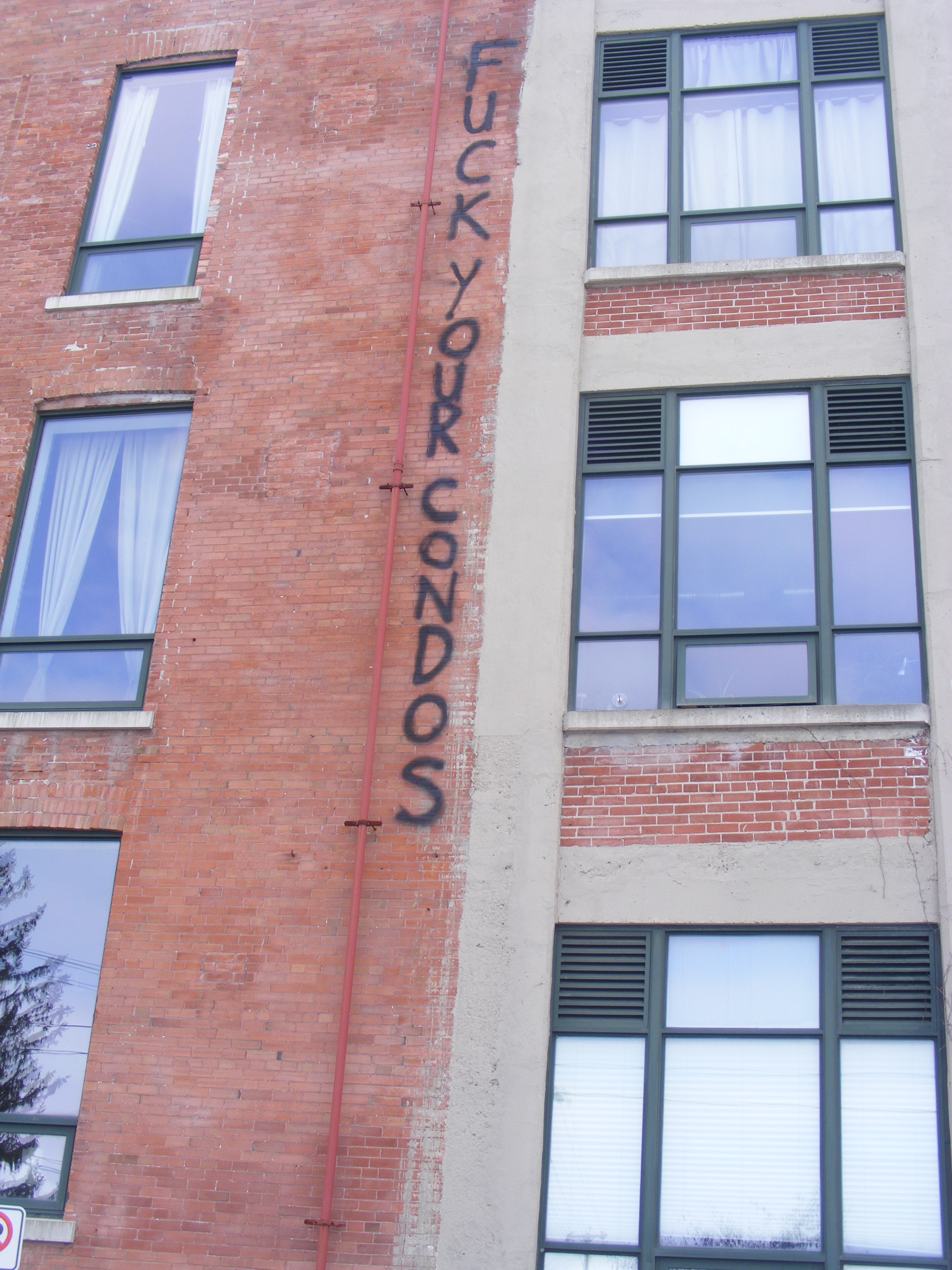
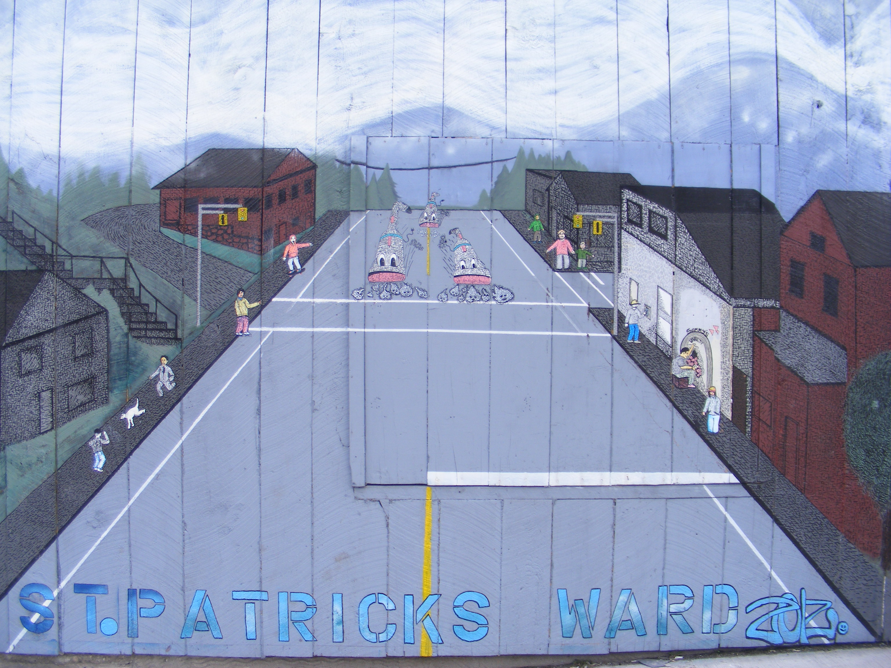
Today I have been very busy working on my final project. Aside from research, I have been experimenting with Omeka. I have written and uploaded some content, however, it does not appear on my website. I believe I have missed something along the way which makes the content I have added to my website public. Nevertheless, I will continue working and hopefully get things up and running (and visible). Aside from that, I have been relatively satisfied with my Omeka experience. The fact that the web publishing software is based around showcasing historical materials works for me as I have no shortage of photos and maps to add to it. One thing that is a little concerning to me is the fact that there does not appear to be a function devoted solely to text. This is not too big of an issue as I can always use items as microcosms of the history of the Ward and just write a lengthy and elaborate description linking the item to its historical context. Thanks to advice I have received from the Wellington County Museum, I have tracked down some excellent sources, one of which is devoted entirely to the Ward, which should help along my research project. Accordingly, a thank you goes out to Nick for suggesting the Wellington County Museum to me. Additionally, a walking tour of the Ward is available from the Guelph Arts Council as well as the Guelph Civic Museum. As I will be at the Museum Wednesday, I plan to defy Professor Ross’ instructions on only using free content and purchase a copy (mostly for my own interests, in addition to the project). This will give me a bit of an idea of what is out there, so I can shape my project in a unique direction. Today, I also took a couple hours to do a lengthy walk around the Ward and take some photos, so I will leave you with some of the most interesting ones. This will also be a bit of a sneak peak as some of these will surely end up on my website: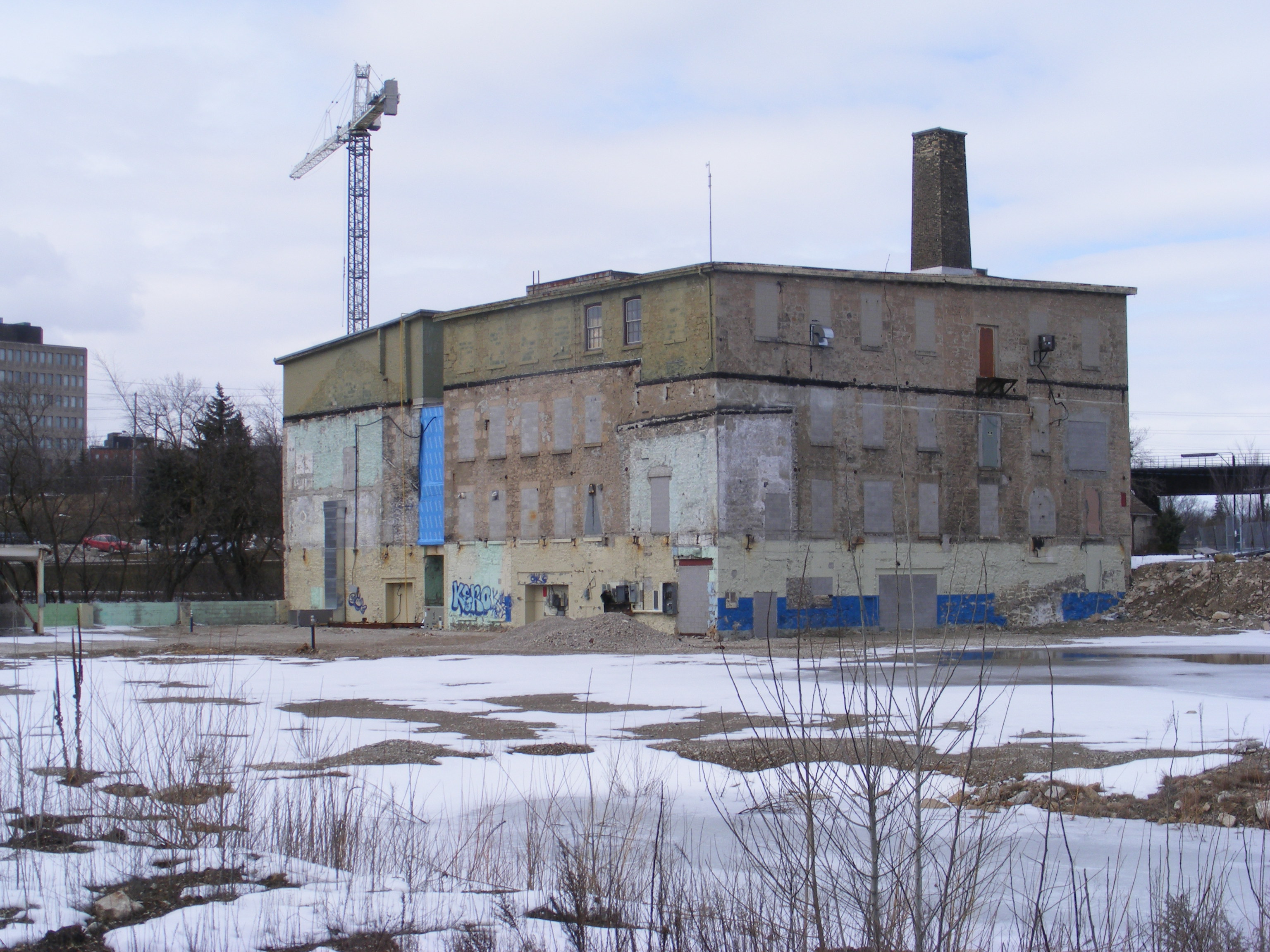
 .
.
As mentioned in my presentation, gentrification is occurring in the Ward and, as you can see, is not a process welcomed by Ward residents.
Final Project Update
At this stage of my project, I am working to develop my map of St. Patrick’s Ward. Most recently I have been doing some work with Google Earth’s image overlay feature. For smaller files, this feature has been excellent and has enabled me to layer several maps very accurately over my Google Earth map of the Ward. Unfortunately, some of the files I am using are enormous and therefore appear as a large red “x” over my Google Earth map. I have tried cropping my maps but for whatever reason when I press save, the image goes blank in the file thumbnail as well as the image itself. I am not sure how to remedy this issue. Compounding my frustration in that regard is the fact that the files are so large that it takes a while for my computer to do anything at all with the image. What I have been doing is, essentially, making a copy of the original file and using that copy to experiment with. If anyone knows, from that description, what I am doing wrong, any advice would be appreciated. Aside from that, the image overlay function works brilliantly for smaller files and I am very happy with the results. My map right now is my central focus as it will hopefully be quite elaborate and will take a fair amount of work. Otherwise, my website will be a medium through which I can provide the public access to materials they might not otherwise have access to. The text element will also be fairly straightforward to me as I am used to the research and writing process. Deadlines are fast approaching, so I am getting rather anxious to get what I am creating finished and on the web but there is still a lot of work to be done.
Final Project Issues
I have encountered some set backs in terms of my final project since my blog post last night. Unfortunately, the Wellington County Museum charges for each photo requested. I calculated how much it would cost me with the number of photos I was interested in and it comes to a total of $112.50. Unfortunately, that will not be happening. The Guelph Civic Museum has a similar system to obtain high resolution copies, however, the museum also mentioned that if I do not need high resolution photos that they can be copied from their website. In this case, I will be sure to state that the photos are courtesy of the Guelph Civic Museum and list pertinent information for those who wish to look the item up on their online catalogue. The Guelph Civic Museum online catalogue proved to be a very fruitful source of information and particularly photographs for me. I will be sure to make use of it. Additionally, the proximity of the museum to home makes it a far more convenient resource in terms of arranging appointments to view particular items. Despite my difficulties with the Wellington County Museum, they did suggest having a look at city directories and tax records at the Guelph Public Library which I will try my best to make time for. All in all, I experienced a few set backs and wasted a bit of time in terms of obtaining material but now I have a better sense of the resources available to me.
Final Project Update
Since my last blog post a lot has happened in terms of my final project. Firstly, i have begun experimenting with Google Earth. I was very impressed with how easy it was to use this software to visualize a particular landscape. Using the polygon feature, I was able to map out St. Patrick’s Ward in translucent green and add some place markers. Additionally, I visited Jenny Marvin who helped me digitize a selection of maps ranging from 1855 to 1989. Furthermore, I am contemplating cropping some of these maps and creating layers of maps over my Google Earth map of the Ward allowing website visitors to gain a truly visual sense of change, especially considering that in the 1855 map, the Ward does not yet exist. I have also visited the Wellington Museum website and have found some excellent photographic resources to use for my website. Some of them are covered by copyright, so I will have to request photos and wait to hear back on their status. I have also contacted the Guelph Civic Museum and will begin searching their collections as soon as I have the time. In terms of research, my efforts have been a bit scattered as I am covering such a vast topic and I am beginning to worry about website content. In terms of web tools, I have set up an account with Omeka which looks to be a good fit for a historical based website. Omeka has an ample array of plug-ins, however, I may need to link visitors to my Google Earth map on my University of Guelph host site. I took a look at Anje’s suggestions for my project and found them to be helpful. I will definitely incorporate a bibliography as well as links where I can. A walking tour should be fairly feasible for me, however, printable versions already exist and, as such, I question how much I would really be adding to the works of others in doing so.
There is a lot of work to be done, but I will continue my work and keep you all updated on what I am up to.
Presentation Review – Anje Merkies’ Early Canadian Cookbooks
Anje has a fantastic idea for a website. One single data base for the university’s cook book collection will be a fantastic resource for researchers and for students to refine their searches and discover new material. Education, research, and engagement are Anje’s three main goals with her website and I think, after seeing what she has developed thus far for her website, that she is on the right track. Providing short write ups for the material posted was a great idea to give people visiting the website an idea of what they will be looking at, especially in light of the chapbooks presentation in which the issue of titles not corresponding to content was raised. I think using tags may also be a helpful way of informing people as to what they will encounter in each cook book. It was mentioned in class before I had a chance to say it myself, but I agree that, in terms of the timeline included on this site that historical context would be helpful at filling in empty space and would expand its usability as well to those who may not be as familiar with historical topics. On Blog Post #7, Anje mentions creating a map. I think this would be a really interesting addition to her site as it would allow users to visualize the sources of the various cook books on the site. If a map were included in the site some local context could be given as well which could help users understand the origins of the cook books and perhaps a better knowledge of their producers as well.
Ultimately, I think that Anje has a very useful idea with a lot of potential. As a student who has done research with the University of Guelph’s cook book collection in the past, I can say through experience that I would have appreciated a website like this. I look forward to seeing the finished product!
Final Project Ideas
After meeting with Jennifer Marvin at the Data Resource Centre I have a few new ideas for my project. Originally, I was thinking of simply creating an interactive map using Google Earth and creating a more research intensive project which draws upon local history more extensively. However, after my meeting I have a few new ideas. Using the University of Guelph archives and the Guelph Civic Museum I could compile a collection of historical photos which I would like to use. Using fire insurance plans available at the library, I could compile some information in terms of workplaces, where they were located, and how this has changed over time. Upon request, I could have maps digitized which I could also include on my website. I could either have a webiste with a more diverse array of media or I could try to integrate these resources into a tour using the manual on Web-Based Mapping Tools that we were given. Most importantly, I now have a traditionally working class target area of Guelph which I would like to examine which is St. Patrick’s Ward or, more informally, “the Ward.” Though I do not yet have much knowledge of the Ward’s history, I should be able to find information from a variety of sources which I have been discovering and am discovering as I type this blog post such as the Ward Residents’ Association and their blog. What’s more: turns out I actually live in the Ward! At this stage, I feel like I have my work cut out for me. I have a more clear idea of what I would like to accomplish, but now my main concern is time. Most of my work thus far has consisted of brainstorming and establishing a clear concept of what I want to to, now I must work through the logistics of making it happen.
Canadian Adaptations of Shakespeare Project and Codeacademy
Canadian Adaptations of Shakespeare Project, or CASP, is a very ambitious project. For any student studying Shakespeare, the applications which CASP is creating are an absolute treasure trove of information and study tools. The CASP project itself, more generally, is a fantastic resource for teachers. With pre-made lesson plans in the Learning Commons section of the website, free access to scholarly articles and essays, and many other teaching tools, CASP is a project which English teachers should not overlook. This being said, CASP goes beyond supplying practical teaching aids, offering an innovative pedagogical approach to the study of Shakespearean plays more generally. With the “‘Speare” arcade game, CASP is working on projects which utilize visual, tactile, and auditory learning styles using a recreational medium to help youth learn. With free content, community engagement, and a generally outward and interactive approach, CASP is a truly innovative and, according to Dr. Daniel Fischlin, an effective approach as well.
This being said, some elements of the CASP project cause me some degree of skepticism in terms of its employment as a class room learning tool. Firstly, the CASP Itunes application for Romeo and Juliet provides scholarly commentary, critiques, and interviews. What makes me reluctant about this is limiting opinion on Shakespeare’s works. I think that the application and future applications should have the capacity for updates, if they do not already have it, to include emerging work on Shakespeare and to broaden the spectrum of opinion available on the application. Additionally, CASP claims that their project will help enhance readers’ understanding of Shakespearean vocabulary by having explanations and translations of particular words available to the user. I question whether such a resource would enhance or detract a user’s understanding of the material they are working with, primarily because it eliminates the necessity of memory if, throughout the work, explanations and translations are immediately available. As we discussed earlier in class, availability of information through electronic devices can fundamentally change how we think. Whether this is positive or negative change, I suppose, is subjective. In terms of the application’s effects on studying, I would be concerned that, with interpretations of Shakespeare’s works, summaries, and other information so readily available, these sources of information may detract from study of the text itself. CASP also claims to enhance comprehension skills, but would it not detract from comprehension skills by comprehending for students through the “Plot” and “Character” sections on the Romeo and Juliet application? These criticisms could be the result of bias or misunderstanding of the project and application, but they nonetheless came to mind when I was reading.
The second component of my blog for this week is on Code Academy’s Learn to Code program. This was a fantastic resource in terms of establishing a step-by-step, easy to follow process to learn how to make a website. In terms of my final project, one of the biggest concerns I had and still have to a lesser degree is making a website. This program eased my concerns somewhat by introducing me to the basics of coding and the language, if you will of the internet. I feel that now that I have the basics down, I am much better prepared to make a website to host my final project.
